Authority hears demonstration of airport operations tracking tools, including statewide data service
Get AI-powered insights, summaries, and transcripts
Subscribe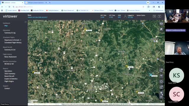
Summary
Staff demonstrated software that maps departures and arrivals and explained a state-sponsored tracking system installed across Tennessee's general aviation airports, which the authority said could help with operations monitoring and planning.
Airport staff demonstrated digital tracking tools that show recent flights to and from the field and described a complementary, state‑sponsored system that aggregates operations data from general aviation airports across Tennessee.
The presentation showed a graphical timeline and map of departures and arrivals for recent periods. Staff said the local tracking tool can be expanded to display longer intervals and that it highlights the airport's "sweet spot" for roughly 500 nautical miles, reflecting the central location of the field. Staff also noted features that can report on approaches, departures and times of operations, and that historical data from a different commercial tool (referred to in the meeting as "Vertower") is available farther back for trend analysis.
Why it matters: the systems help the airport monitor activity, support operations planning, inform marketing, and provide comparative statewide statistics on general aviation operations.
Key points from the demonstration - Staff displayed mapping that showed flight origins including major metro areas and occasional long trips (examples cited included New York and Panama City). - The authority was told a state‑sponsored tracking service has been installed at Tennessee general aviation airports and that it supplies statewide comparative reports; however, the local system gives more granular detail for the airport’s own operations. - Staff said the tools can produce reports the airport's consultant and FAA teams can use for tower justification and other planning tasks; staff reported providing such data to the airport's consultant working with the FAA.
Limitations noted Staff said local tracking sometimes shows flights not captured by other services and conversely that the state system does not provide the same level of specific trip detail for other airports. Military and flyover traffic and procedural limitations in radar coverage were cited as factors that can affect operation counts.
Ending Members thanked staff for the demonstration and suggested showing the systems to other local stakeholders and municipal IT staff to support operations analysis and occasional public demonstrations.