Commission approves alternate compliance for four‑parcel map; neighbor warns of future subdivision, traffic and private-access impacts
Get AI-powered insights, summaries, and transcripts
Subscribe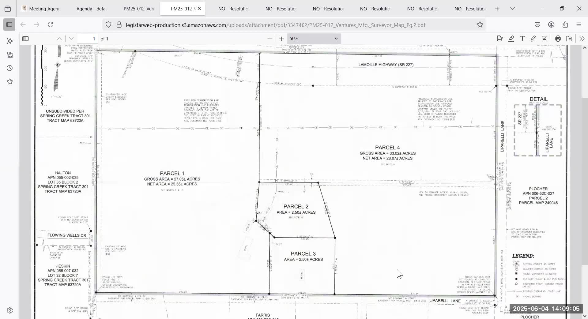
Summary
Planning staff recommended, and the board approved, an alternate-compliance request allowing private access easement for two new parcels on a four‑parcel map for land owned by Ventures Lands Ventures Inc.; a neighboring property owner raised historical and access concerns and warned the parceling could be the first step toward larger subdivision.
The Elko County Board of Commissioners approved an alternate-compliance request from Ryan Cook (Summit Engineering) on a parcel map that would split one existing parcel into four and allow a private access easement to serve parcels 1 and 2 instead of dedicating a 30-foot access easement to the county.
Corey (planning staff) explained the map: the applicant proposes a private access easement traversing from the east boundary on Liparelli Lane to serve parcels 1 and 2; staff recommended approval of alternate compliance but noted the county will send notice to the 30 closest property owners and provide a 30-day appeal period if the board approves the request. Planning staff also noted that parcel map approval triggers a 30‑day notice and appeal window; the board has a 45‑day technical review period during which staff checks the map for technical compliance with the code.
Neighbor Marilyn Tipton told commissioners the 54-acre property had been deeded in 1976 with a clause she described as restricting subdivision, and she said the land has been kept as a single parcel through multiple owners until the current purchaser. Tipton said existing development has relied on private easements and a homeowners’ agreement for road maintenance (Liberally Estates) and that the proposed parceling and future development would seek to use access through her subdivision rather than other points of access. Tipton said the parcel had multiple structures that were erected while zoning was not enforced and warned the current map approval is “just the first step” toward a larger conversion to 2.5-acre parcels. She said she had requested the county review historical conditions and access rights before allowing further division.
Staff told the board the parcel map will require relinquishment of water rights per state rules: “They will have to relinquish 2 acre feet of water rights for each new parcel created, which would be 3 new parcels. So it'd be a total of 6 acre feet of water rights that they'll have to relinquish back to the state for this parcel map.” The planning staff also said Parcel 3 currently accesses Liparelli Lane to the south and that the part of Liparelli Lane running east-west is recorded as public access and utility easements but not dedicated county right-of-way.
Commission discussion focused on the limits of a parcel map (it may create up to four parcels) versus a subdivision (which would require additional review, development agreements and road improvements). Commissioners noted that future subdivision would require formal road improvements and a development agreement; that is the stage at which the county can require road upgrades and contributions. One commissioner said he saw “no reason to deny this at this point” and moved approval; the board approved the alternate compliance request and staff will send the notice of approval with appeal instructions.
Ending: The board approved the alternate-compliance request by voice vote and staff will send notices to nearby property owners; neighbors have 30 days to appeal the map approval and any future subdivision proposals would require road-improvement commitments and potential development agreements.