Provo presents sidewalk, intersection and bridge projects including 20 North Ridge bridge and refuge islands
Get AI-powered insights, summaries, and transcripts
Subscribe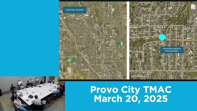
Summary
City engineers briefed TMAC on multiple capital projects: a 20 North Ridge bridge project (plans at 90%), refuge islands, school-area sidewalk work, CDBG-funded traffic signal at 1500 North/400 East and a multiuse path on 600 South tied to the university bridge work.
Provo City engineers presented a bundle of capital sidewalk, intersection and bridge projects to the Transportation Mobility Advisory Committee, including the 20 North Ridge bridge, refuge islands and several school‑area sidewalk connections.
Staff said the 20 North Ridge project is at roughly 90% plan completion; the city is preparing bidding documents and expects construction to begin in the late summer or fall, with a detour route routing traffic via Independence Avenue and Fifth West onto Fifth North. Staff estimated the bridge work could take six to nine months and said pedestrian detours (ADA ramps and temporary trail routing) will be in place before construction begins.
Other projects covered:
- Sidewalk improvement bundle: includes Apple Avenue/Locust Lane intersection improvements, a refuge island at 560 North/900 East, curb and gutter repairs, ADA ramp upgrades and additional lighting. The refuge island is designed to limit east–west vehicle movements at the crossing and provide a pedestrian refuge.
- CDBG-funded projects: Staff said the city received Community Development Block Grant (CDBG) funds for 1500 North/400 East ($~250,000) where a traffic signal is now warranted by traffic analysis; and for 6 North/400 East (Joaquin intersection) where curb, lighting, re-striping and storm improvements are planned.
- Lakeview Parkway / 2000 North and Canyon Road: Utilities are substantially in place for Lakeview Parkway; staff will construct two-lane roadway sections and complete sidewalks and connections at key school crossings on Canyon Road to eliminate mid‑block crossings near Foothill Elementary and other schools.
- 600 South multiuse path: Staff described a two‑phase project to build a 10‑foot multiuse path from the railroad area to 400 East; the path will tie into future University bridge work by UDOT. Staff noted coordination is required with Union Pacific Railroad and UDOT and said the path will be 10 feet where right-of-way allows but will narrow at constrained segments.
Consultant and construction coordination questions focused on detour routing, pedestrian accommodations during bridge work and whether planned map graphics accurately show where facilities can physically connect. Staff agreed to refine maps to remove connections that cannot be realized because of right-of-way or bridge geometry.