Fire Department Transforms Emergency Response with GIS Technology
October 05, 2024 | SeaTac, King County, Washington
This article was created by AI summarizing key points discussed. AI makes mistakes, so for full details and context, please refer to the video of the full meeting. Please report any errors so we can fix them. Report an error »
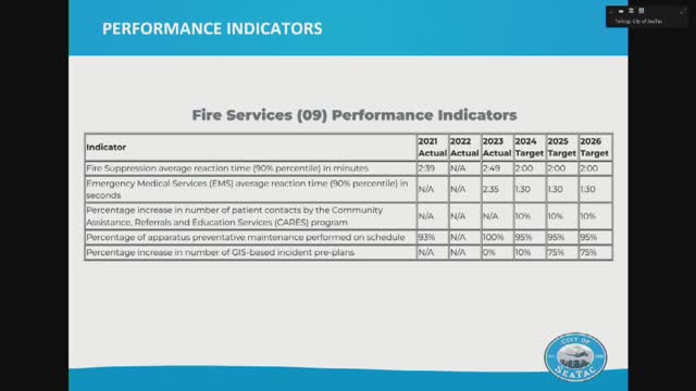
While the transition to this new system is promising, officials noted that implementation is slow. Fire crews must physically visit each building to input specific data points, such as locating stairways and fire alarm panels. Despite the challenges, the department is optimistic about the improvements this technology will bring to their operations.
The meeting also addressed the financial complexities associated with the growth of Puget Sound Fire since the city’s annexation and contracting changes in 2014. Officials highlighted the need for transparent and fair cost allocation across various jurisdictions, including directly annexed stations and contracted services. The discussion underscored that no single agency can subsidize another, emphasizing the importance of equitable funding as the fire department continues to expand its services.
View full meeting
This article is based on a recent meeting—watch the full video and explore the complete transcript for deeper insights into the discussion.
View full meetingSponsors
Proudly supported by sponsors who keep Washington articles free in 2025

